Taste-filled Travel
  • Home
  • Who We Are
  • Blog
    • Aruba >
      • 6 Must-try Places in Aruba
    • Europe >
      • Budapest, Hungary
      • Bratislava, Slovakia
      • Iceland >
        • The Ultimate 4-day Road Trip
      • Prague, Czech Republic
      • Vienna, Austria
    • USA >
      • Maine >
        • 24 hours in Portland, ME
      • Massachusetts >
        • Cape Cod >
          • Sandwich, MA
        • Salem, MA
      • New Hampshire >
        • 7 Scenic New Hampshire Hikes
      • Southwest >
        • 9-day Southwest Road Trip
    • Virtual >
      • 5 Virtual Ways to Get Creative This WInter
  • Itineraries
  • Get In Touch
  • Let's Get Social
  • Referral Discounts
Search by typing & pressing enter

YOUR CART

The Ultimate
9-day Southwest, USA
​Road Trip

6/28/2021 3 Comments

The Ultimate 9-day Southwest, USA Road Trip


It had been 14 months since our travel plans came to an abrupt halt due to Covid-19. With many countries closed to US travelers, we decided to use it as an opportunity to explore our own country, the USA. After extensive amounts of research and planning, we were READY. While we had been to Utah, Nevada, and Arizona before, we had never explored it quite like this. Below, I will map out our 9-day road trip throughout these states, full of must-see sights, good eats, and unforgettable hiking. *To bypass reading this entire post, click here for our full itinerary.
9-day Southwest, USA Road Trip Itinerary
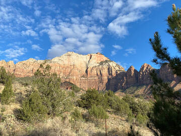
We set out early from Las Vegas, NV. Our final destination for Day 1 was Zion National Park, but we would be making numerous stops on the way, so there was no time to be wasted. 
Valley of Fire State Park
Our first stop was Valley of Fire State Park, only about an hour outside of Las Vegas and a perfect start to our trip. We hiked the Fire Wave Trail for about an hour, full of red sandstone formations and gorgeous waves of color. This was an easy, very picturesque hike and a great alternative to hiking the popular “Wave” trail which requires a permit distributed through a lottery.
Valley of Fire State Park
We took some photos on the famous Mouse’s Tank Road. Pro tip: Get there early to avoid cars in your shots! We were lucky enough to only have a few passing cars here and there. The great thing about this park is you could spend 2 hours or a half-day there depending on your schedule. Its unique beauty is not something you want to miss.
Mouse's Tank Road
Mouse's Tank Road
​Next stop was the Coral Pink Sand Dunes State Park in Kanab, UT. While we only did a short hike to the dunes to enjoy the scenery, this park offers sand boarding/sledding and ATV tours (which looked like a blast!). It's definitely worth seeing, even just for a quick stop on your way to your destination.
Coral Pink Sand Dunes
The Great Chamber
The Great Chamber
While in Kanab, we took a tour to The Great Chamber, a giant sand dune hidden within a cove. What a sight! After driving up winding, sandy roads, we reached the trailhead. While it was only a short ¼ of a mile, the hike was uphill and mostly in sand, but absolutely worth it. The cave was breathtaking and echoed our awed voices as we approached it. The entire tour was about 3 hours, including driving time and photos. Kenny, our tour guide, was friendly and full of knowledge, greatly adding to our overall experience. (Full tour details here)
​Before continuing our drive to Zion, we stopped at a family-owned Mexican place for dinner. The portions were huge and the food was tasty and much needed after a long first day of exploring. 
We arrived at our hotel in Springdale, UT an hour later and prepped for our fun-filled day to follow at Zion National Park.
Mexican food dinner
Zion National Park Mountains
We awoke the next morning to the sun illuminating the gorgeous mountains and canyons that make up Zion. Everything was so vast; it took your breath away. 
We were so excited for the day’s event. We were hiking The Narrows. If you’re not familiar with The Narrows, it’s home to the narrowest walls within Zion Canyon, stretching 1000 ft. high and sometimes only 20 ft. wide. Through this gorge runs the Virgin River, which is essentially the trail. That’s right, you hike through the actual river. Due to snow melt and rain, April is typically a tricky time to hike The Narrows as it can be closed due to flooding. Lucky for us, we had a dry couple of weeks leading up to our stay and the forecast for the day showed no rain in sight.
The Narrows Hike
The Narrows Hike
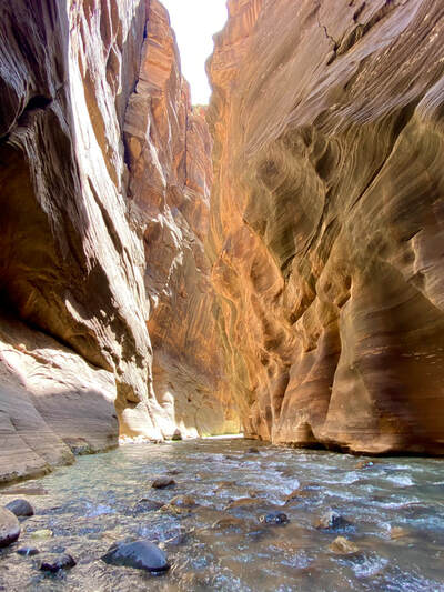
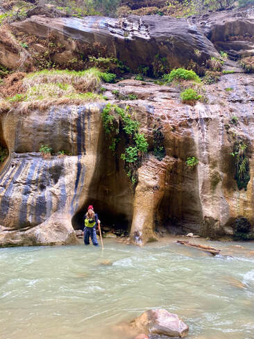
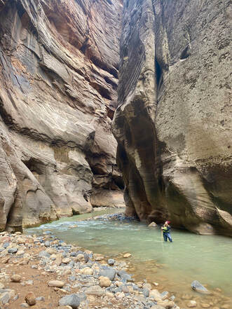
There are two ways to hike The Narrows. First is the “Top-Down hike”, which requires a permit and is often suggested to camp overnight as it’s 16 miles and not recommended for a day hike. We chose option #2, called the Bottom-Up hike. This does not require a permit and can be done as a day hike, giving you a 10-mile roundtrip.
Biking in Zion Canyon
Rather than dealing with shuttle tickets to take us to our starting point, we opted to rent ebikes and peddling to the trailhead. BEST. DECISION. EVER. I was a little hesitant at first as I am no triathlete and the thought of biking 7 miles to the trail head, walking another mile to the river, and hiking 10 miles wading through water and rocks, all to hike back to the bikes and peddle 7 miles back was a little intimidating. I’m so glad we chose to do it. It was amazing to have the freedom to stop along the way and take in the views as we rode through the canyon. I will say, although ebikes are more expensive than renting a regular bike, it was worth whizzing uphill as we watched non-ebikers struggle. It was a great way to tour the canyon while still preserving energy for our hike ahead AND it saved time.
Make sure you’re prepared and once you're at the river, expect to get wet! Rent the gear, bring layers, pack more than enough snacks, and water, water, water. The last thing you want is to be hiking in a breathtaking gorge and have to turn around because you’re cold, hungry, or dehydrated. You can find a full packing list with gear recommendations here. 
Hiking The Narrows in the Virgin River
Wall Street in The Narrows
While we didn’t hike all the way to the Big Springs, which is the furthest point you can go without a permit and requires some swimming, we went a bit past the famous “Wall Street”. Here started the narrowest part of the canyon, which is less crowded and consists mostly of knee-deep water.
The recommended time to hike The Narrows is Spring and Summer, when the water temperature has risen some. This was a truly unique and unforgettable day that I was so fortunate to have been able to experience. ​(Full hike details here)
We peddled back down through the canyon, enjoying the views and stopping along the way for photos. Not ready to return our bikes just yet, we stopped at the Zion Brewery for some much-earned fresh beers before our evening hike. The brewery was casual, with an adorable outside area to bask in the sun. We fueled up on snacks, returned our bikes and gear, and headed out for our sunset hike at the Canyon Overlook. 
Beer flight at Zion Brewery
Do not skip this! It was a short hike, about 2 miles, and although it was somewhat steeper than people let on, the view was breathtaking. We sat watching the sunset and reminisced about the incredible day we’d just had, taking in every last drop of sunlight. (Full hike details here)
Sunset at Canyon Overlook
​The next morning, we grabbed breakfast burritos for the road and headed out to Bryce Canyon National Park. We only had a few hours here as it was a stop on our way to Moab, UT. It was another gorgeous day for exploring. We parked at Sunrise Point and, as if the view couldn’t get any more picture perfect, we were greeted at the trailhead by a group of horseback riders. A photobomb I happily welcomed. 
Horseback riders at Bryce Canyon
Orange spires at Bryce Canyon
Spires at Bryce Canyon
We began our trek down into the canyon, passing bright orange hoodoos and spire rock formations. Every corner was more scenic than the next. We hiked the Queens Garden Trail down to the Navajo Loop and back up through the Two Bridges Trail, ending at Sunset Point. Our original plan was to hike through Wall Street but it was closed due to rock fall.
The last 15 minutes of the hike was the toughest as it involved steep switchbacks and very little shade. Definitely remember to bring a hat and sunscreen for this one! I was completely blown away by Bryce. I hadn’t expected to be as it was not highlighted as much as the other national parks. Even though we only had a few hours to explore, we easily could have spent the day here.  (Full hike details here)
Switchbacks at Bryce Canyon
It was time to hit the road again. We set out for a lengthy (but beautiful) drive ahead. We drove through Capitol Reef National Park and, although we didn’t have time to hike any of the trails, the lookout points were breathtaking! Massive walls of oranges and reds surrounded us, making it very hard not to stop and explore. 
The Fluted Wall at Capitol Reef National Park
We arrived at our last stop before reaching Moab, Goblin Valley State Park. This was a recommendation from a friend and we were so glad we made time to go. Once surrounded by the ocean 170 million years ago, Goblin Valley was formed by a combination of waves that deposited sand, silt, and clay, and pressure, which hardened into these formations over time.  
Goblin formations at Goblin Valley State Park
Sunset at Goblin Valley State Park
We got there just in time for sunset and it was such a unique experience. We had the entire park almost to ourselves and were able to weave in and around the unusual goblin-like creations like little kids. It was such a fun place to end the day and enjoy a beverage as the sun went down. 
We woke up early the next morning, excited to explore our first park in Moab, UT, Arches National Park. Located 5 minutes from our hotel, we went over right from breakfast. I recommend getting there as early as the park allows to avoid waiting in line to get in. Our first hike would be on the Devils Garden Trail to reach the Double O Arch. On our way, we passed the Landscape Arch, which partially collapsed in the early 90’s, leaving a section extremely thin. 
Landscape Arch
Landscape Arch
Climbing
Rock Scrambling
This hike involved a bit of scrambling up rockface but was enjoyable and had great views. Double O was one of our favorite arches in the park. Pro tip: If you climb through to the other side (this is allowed), you get a view of the entire arch with the landscape in the background. We ate lunch while taking in the scenery, before making our hike back. 
Double O Arch
Double O Arch
From here, we headed to The Windows Section, making a couple of stops on the way for photos. This section includes the Double Arch, North Window, South Window, and Turret Arch. This is family/kid friendly involving little to no hiking and the distance to each arch is very short. We really enjoyed exploring these arches and taking a much-needed break before our sunset hike to the Delicate Arch.
Arriving at the Delicate Arch trailhead a couple hours before sunset, we couldn’t contain our excitement. This hike had been recommended by a friend and it was some of the best advice we had received for Moab. While the hike was only 3 miles round trip, it was mostly at an incline, making it more challenging than some of our longer hikes. WOW, was it worth it. Unsure how much longer we had to get to our destination, we turned a final corner of the narrow path to a view that was unlike any other; The Delicate Arch. 
Path leading to Delicate Arch
Joining the groups of photographers and other tourists, we made ourselves comfortable and watched as the colors and light changed over the two hours we spent there. It started a bit overcast until the sky opened up and the sun illuminated the arch magnificently. As the sun began to set, it released a palette of soft pastel purples and pinks, making it a truly magical experience.
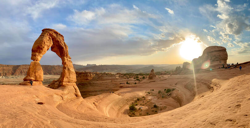
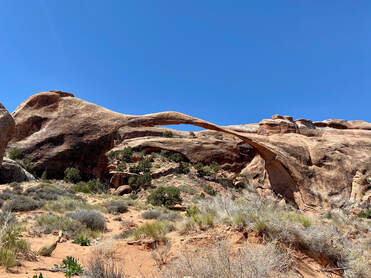
Delicate Arch at sunset
Exhausted from our rewarding day of hiking, we reflected on the day over a beer and burger at Moab Brewery. The casual vibe, refreshing beer, and delicious food was the perfect way to end such a memorable day.
Burger
"The Monster"
Shafer Road
Shafer Road
The next day, we set out to Canyonlands National Park. While this park has three districts you can visit, we chose “Island in the Sky” based on our schedule and its vicinity to Dead Horse Point State Park which we also planned to visit that day.
We stopped at many view points throughout this park but the highlight for us was the famous Mesa Arch. While it’s said to be amazing at sunrise, we are not early risers and got there a few hours after sunrise. The view was still gorgeous and worth the short mile hike to see it. ​
Mesa Arch
Mesa Arch
From here, we drove over to Dead Horse State Park, which we felt was very underrated. Had we known how many beautiful sights and trails there were, we would have planned to spend more time there. From one of the lookouts, there was a view of the Colorado River and Solar Evaporation Ponds in the distance. We had read about them but seeing them in person was even better. 
View of the Colorado River from Dead Horse State Park
View of Solar Evaporation Ponds from Dead Horse State Park
These ponds were formed from Potash (potassium chloride), a salt deposited from ancient seas as it evaporated and was buried by sediment. Water is pumped into the ponds to dissolve the salt, and blue dye is added to speed up the evaporation process. The salt is then harvested and transformed into plant fertilizer.
The next morning, we said goodbye to Moab, UT and began our scenic drive to Lake Powell in Arizona. We gave ourselves enough time to make some stops along the way and although Monument Valley Navajo Tribal Park was closed to visitors, driving through it was something out of a movie (literally). This is the famous road, also known as “Forrest Gump Road”, where Forrest ended his cross-country run in the 1994 film, “Forrest Gump”. More route information here. 
View of Monument Valley Navajo Tribal Park
Upon arrival at Lake Powell, we picked up our previously rented kayaks and started our paddle to Antelope Canyon. The lake was smooth and clear and the warm, sunny Arizona weather made for a picture-perfect day on the water. We entered the canyon, docked our kayaks, and began our hike. Depending on your timing, you can choose to hike as far into the canyon as you’d like, as long as you leave enough time to paddle back and return your kayaks.
Kayaking on Lake Powell
View of the canyon
View inside Antelope Canyon
This was an experience we had really been looking forward to. To witness this slot canyon up close was such a unique experience. The further we hiked, the more and more narrow the walls became. The sun beamed through the crevices as we weaved in and out of the formations, each one different from the last.
Although we could have spent hours longer hiking into the slots, we knew we would have to hike back the way we came to ensure we returned the kayaks before closing. For rentals, full paddling and hiking information, and timing, click here.
View inside Antelope Canyon
Our stay at Lake Powell was short but sweet and it was time to head to the Grand Canyon National Park. On our way, we stopped at Horseshoe Bend, which is a sight you don’t want to miss! As you approach the 1000 ft. deep meander, it fills you with awe. Seeing the boats and kayaks in the Colorado river surrounding it put into perspective just how giant this bend is.

​We took some photos and sat for a while, taking it all in before we continued our road trip. It was a short and easy stop to make and I highly recommend including it in your itinerary.
Horseshoe Bend
Horseshoe Bend
Horseshoe Bend
Horseshoe Bend
We arrived at the Grand Canyon National Park (South Rim) and immediately began our first hike on the Bright Angel Trail. I had been to the Grand Canyon as a child but there was something about hiking into the canyon that made it feel like a brand-new experience. There are three turnaround points during this hike. We had initially planned to hike down to the second stop but halfway down, it began to rain and hail, making everything very muddy and slippery. Even with the rain, the views were spectacular and we saw a rainbow once the storm had passed. We turned around at the first stop and finished our wet hike back toward the top.
Bright Angel Trail
Bright Angel Trail
Young Deer
The plus side to the inclement weather was how few people were around. With less people on the trail, several deer appeared and we quietly took pictures of them without groups of people to startle them. (Full hiking details here)
Day two at the Grand Canyon was our long hike on the South Kaibab Trail, the highest point being 7,200 ft. in elevation. There are three turnaround points on this trail as well. The first stop, “Ooh-Ahh Point” is a good spot to turn around if you have young children or are only looking for a quick hike. The further down you go, the less crowds you’ll encounter. 
Ooh Aah Point
Ooh Aah Point
We went to the third stop, Skeleton Point, and soaked in the 360-degree views of the canyon, as well at the Colorado River. Most of this hike was fully exposed to the sun so make sure to bring plenty of water, sports drinks, and salty, protein-filled snacks. We ate our packed lunch at Skeleton Point and refueled before heading back up to the rim. 
Skeleton Point
Skeleton Point
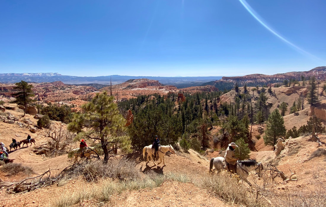
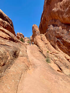
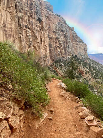
Also, make sure to respect the mules on your way up and down, as you’ll be sharing the trail with them at times. (Full hiking details here)
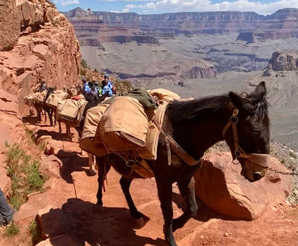
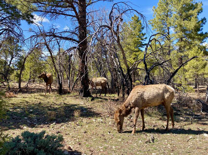
Mules at the Grand Canyon
Another thing we loved about the Grand Canyon, aside from the hiking and beautiful views, was the amount of wildlife we encountered, specifically the elk. Everywhere we turned, there were elk grazing. It’s illegal to approach or feed the animals within the park so they were very calm around humans, allowing ample amounts of photo ops.
Elk at the Grand Canyon
Beers
After having a post-hike drink and snack at the Yavapai Lodge, we went to Yavapai Point to watch the sunset. The canyon filled with bright orange and pink colors, making an ideal spot for a relaxing ending to our action-filled day.
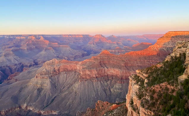
Sunset at the Grand Canyon
Waking up on our last day was challenging, as we were not ready to leave. We had a redeye flight home so we were determined to make the most of the time we had before heading to the airport. We packed up and began our drive to the Hoover Dam. 
Hoover Dam
Hoover Dam
View from the Hoover Dam
The Hoover Dam is on the border of Arizona and Nevada and controls the flow of Lake Mead, the largest reservoir in the US when full. Typically, tours are offered that take you through the different levels of the dam. Unfortunately, tours were closed due to Covid-19 but are worth checking out once they open again.
View from the Hoover Dam
From the Dam, we went to the Arizona Hot Springs, also known as Ringbolt Hot Springs. Once at the springs, there are three different pools. Depending on which direction you hike from, the pools get cooler or warmer as you go. ​We entered into the springs and waded through the water as this is the only way to continue on the trail.
Arizona Hot Springs
Arizona Hot Springs
Once we were through the pools, we climbed down a ladder and through a small stream until we reached the rest of the trail. The views of the Colorado River were stunning. While we had seen the river from various stopping points throughout the trip, this was the first time we were seeing it up close and able to touch the water. It’s emerald green color and icy temperature was refreshing after such a strenuous hike.
Arizona Hot Springs
Colorado River
Colorado River
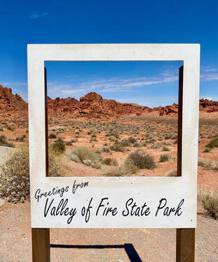
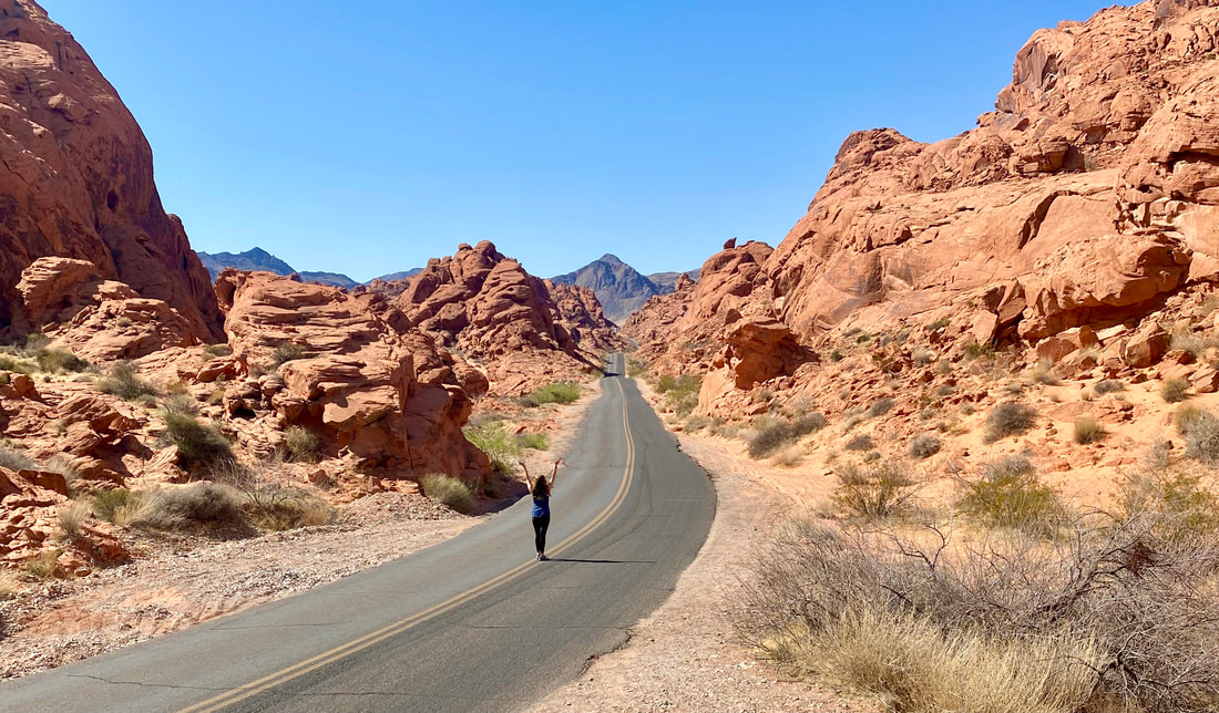
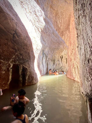
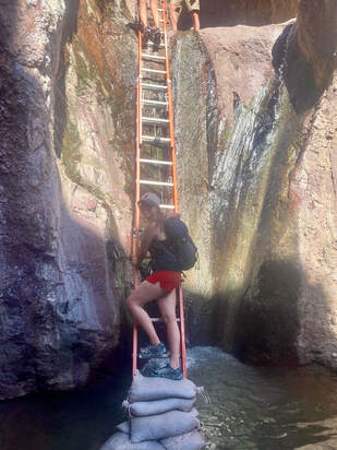
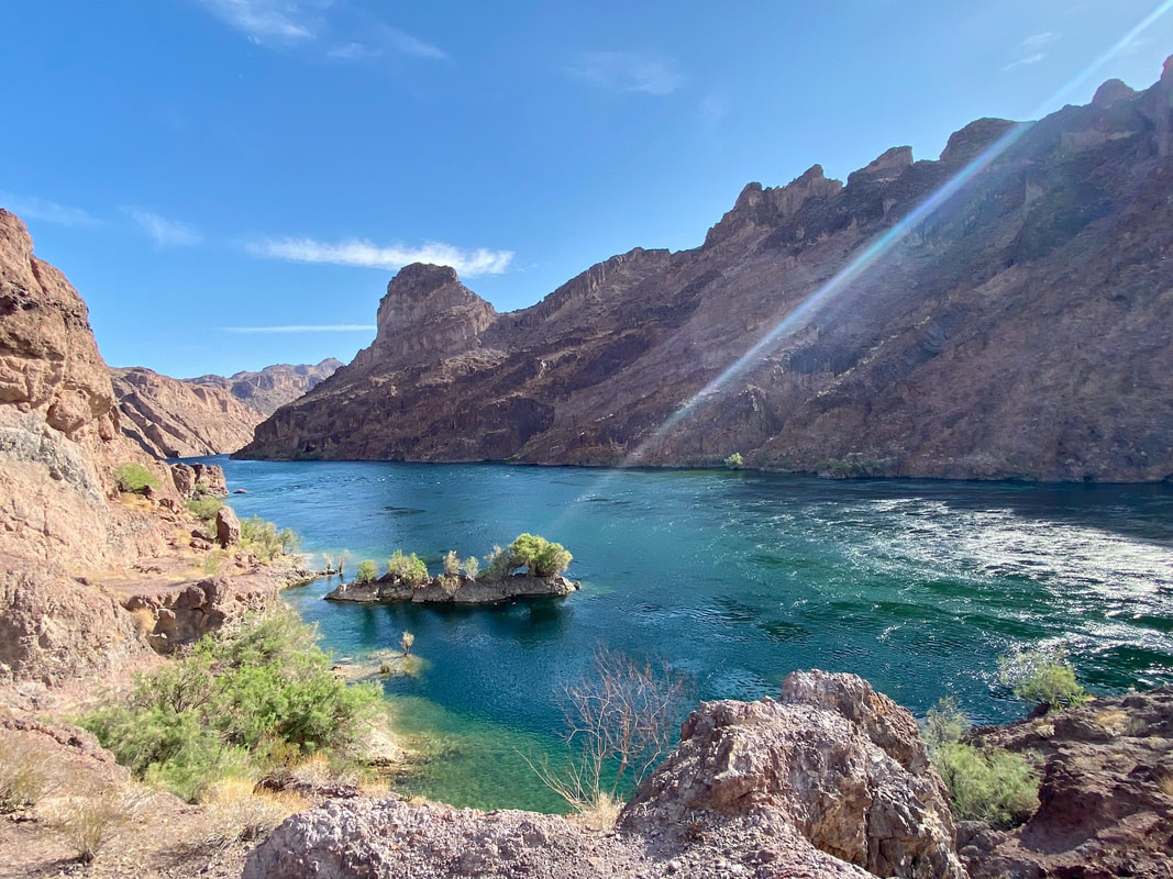
Something to note, the trails to the hot springs were very poorly marked and there was zero cell service so, should you choose to conquer this hike, make sure you do your research and map it out in advance. Like the other hikes, pack plenty of water and food as the Nevada sun is strong and there is very little shade. (Full hiking details here)
We stopped by a local brewery on our way to the airport to cool off and enjoy our last meals and drinks of the trip. It was a beautiful and breezy night, making it that much harder to leave. 
Outside of brewery

If you enjoyed this blog, please comment & share!
​For full trip details, click here to purchase our complete 9-day itinerary.

3 Comments
    This post contains affiliate links. To find out more information, please read my Privacy Policy. If you have any questions or suggestions, please contact me.

    Categories

    All Arizona Nevada Southwest Road Trip Utah

    RSS Feed

Proudly powered by Weebly

Copyright ©2024 Taste-filled Travel | All Rights Reserved